Agricultural Services
Overseed pasture, interseed cover crops, control weeds with targeted drone spraying, and map vegetation health — on the slopes, burn scars, and remote ground that ground equipment can't touch.
Quick Quote
Name, contact, acreage, terrain — that's it. We’ll reply within one business day with a line-item quote.
Flagship Service: Drone Aerial Seeding
Mountain West Drone Services puts native seed, cover crop, and granular fertilizer exactly where it needs to be — on steep slopes, burn scars, reclamation pads, pipeline corridors, and remote pastures that tractors can't reach and helicopters can't afford to cover. A heavy-lift platform with a calibrated 50 kg broadcast spreader, terrain-following radar, and autonomous flight paths lays down seed with a consistency that's hard to match from the ground — and impossible from a helicopter at this price point.
The Drone Seeding Advantage
We fly a professional-grade heavy-lift agricultural platform engineered for heavy-payload spray and broadcast operations. Paired with a 50 kg broadcast spreader, active phased-array radar for terrain following, and autonomous flight planning, it lays down seed with a consistency that's hard to match from the ground — and impossible from a helicopter at this price point.
No ruts. No compaction. No mobilization damage. Just even, verifiable seed coverage — measured in acres per hour, not days per field.
Full Aerial Seeding DetailsWhere Drone Seeding Shines
The places that most need aggressive reseeding — steep slopes, post-fire burns, pad closures, remote pastures, pipeline right-of-ways — are exactly the places traditional seeding methods struggle.
Oil and gas pad closures, mine reclamation, and disturbed-land restoration on terrain ground equipment can't touch.
Rapid emergency seeding on burn scars before the first rain. Protect watersheds and jump-start recovery.
Interseed cover crops into standing cash crops, overseed pastures, and establish new forage stands.
Reseed linear disturbance corridors without driving equipment down the trench. Meet reclamation obligations cleanly.
Broadcast native seed across reshaped highwalls, backfill slopes, and regraded benches — no rollover risk.
Restore degraded rangeland and reseed streambanks without driving through the ground you're protecting.
What We Broadcast
Variable-rate flow control lets us calibrate the 50 kg spreader to your specified mix and target application rate. We deliver an as-applied coverage map with every job so you have the documentation you need for reclamation records or regulatory review.
Reclamation-spec native seed blends calibrated to your target rate.
Rye, triticale, radish, vetch, clover, and custom cover blends.
Alfalfa, orchard grass, brome, and mixed pasture establishment.
Pre-mix and broadcast fertilizer application at specified rates.
Our Process
We talk through your seed mix, target rate, acreage, and timing. If needed, we walk the site or review recent imagery to confirm terrain, obstacles, and staging. You get a clear, line-item quote — no surprises.
We design a terrain-aware flight plan, set the broadcast pattern and overlap to hit your target rate, handle airspace authorization, and calibrate the spreader to your specific seed.
We mobilize, pre-flight the aircraft, and execute the plan. The aircraft runs terrain-following lines autonomously. You receive a coverage map and as-applied report when the job is done.
Aerial Seeding Quote
Tell us the acreage, terrain, and seed mix — we’ll return a clear, line-item quote. Most estimates back within one business day.
Free estimate. No obligation. Typical turnaround: 1 business day.
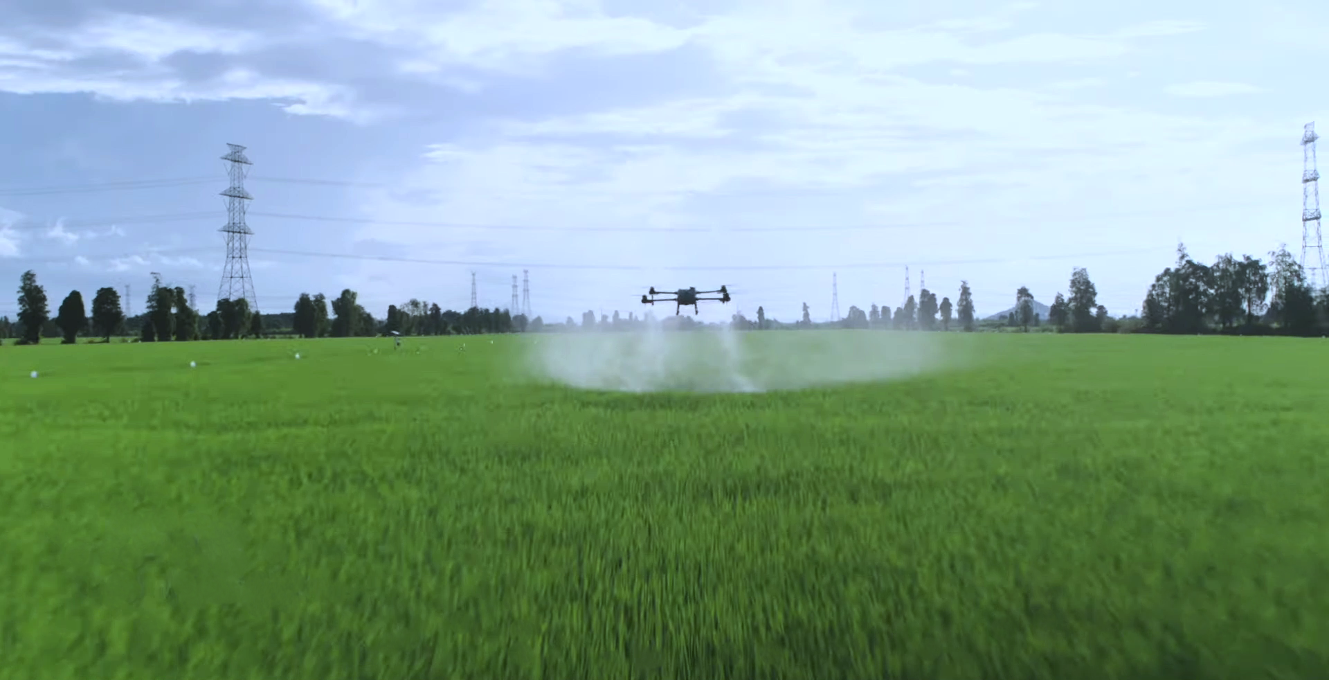
Precision Drone Spraying
Our spray configuration pairs a 40 L tank with twin rear-mounted rotary atomizers, active phased-array radar for terrain following, and variable-rate flow control. Adjustable droplet sizing keeps product on target and drift down — and the aircraft holds a consistent height over slopes, draws, and broken ground no rig can drive.
No wheel tracks through your pasture. No soil compaction. No waiting on a plane that won't fly your acreage. Up to 21 acres per hour, with an application record on every job.
Spray tank
Rotary atomizers
Coverage, up to
Rate & drift control
Common Applications
Also Available
Dedicated multispectral platform with integrated 4-band multispectral and RGB sensors. Captures NDVI and other vegetation indices that reveal crop health, stress patterns, irrigation issues, and pest or disease pressure — information invisible to the naked eye. RTK-capable for survey-grade positioning accuracy.
Deliverables
Certified. Equipped. Local.
Aerial application isn't a side hustle — it's a regulated, Part 137 agricultural aircraft operation. We carry the certifications, the equipment, and the local terrain experience to do it right.
Certified agricultural aircraft operator — the credential required for commercial aerial seeding and spraying by drone.
Professional-grade, heavy-payload agricultural platform with 50 kg broadcast spreader and 40 L spray tank.
Local to Moffat County and Northwest Colorado. Fast mobilization on post-fire, weather-driven, and seasonal jobs.
1st Place — 2023 Craig Business Plan Competition. Fully insured and ready to put on site documentation.
Service Area
Core service area: Moffat County and Northwest Colorado — including the Yampa Valley, White River drainage, and Routt, Rio Blanco, and Garfield counties. We also travel regionally across Colorado, Wyoming, and Utah for projects that are a good fit. Mobilization is always quoted transparently up front.
Core Area
Moffat County
Northwest Colorado
Regional
Western Colorado
Front Range
Interstate
Wyoming, Utah
Mountain West
Certifications
FAA Part 107
Part 137 Ag Ops
Dig Deeper
Flagship Service
Platform specs, workflow, case-study scenarios, and pricing context for aerial seeding projects.
Explore the service →Complete Guide
How drone aerial seeding actually works — and when it beats a drill, ATV broadcaster, or helicopter.
Read the guide →Wildfire Restoration
BAER coordination, native seed mixes, and the post-fire reclamation timeline — real-world workflow.
Read the story →Aerial Seeding Quote
Tell us about the site, seed mix, and timing. We’ll return a clear line-item quote — typically within one business day.
Free estimate. No obligation. Typical turnaround: 1 business day.